Choosing Zones in SPCS2022
Deciding What Zone Fits Your Project
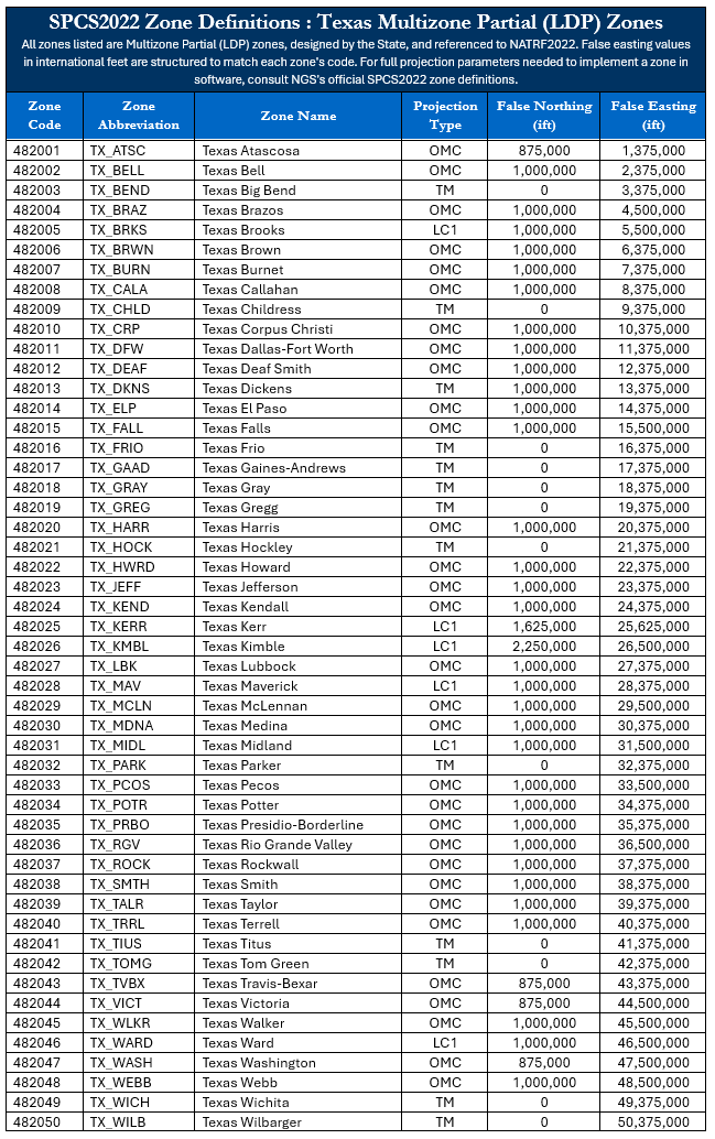
Texas now has three SPCS2022 zone layers: one Statewide Zone, the familiar Five-Zone called Multizone Complete, and 50 Low Distortion Projection (LDP) zones called Multizone Partial. This means you have 56 zones to choose from in SPCS2022 versus the 5 zones we have in SPCS83. This guide is intended to provide you with general information about Texas’ SPCS zone layers and to help guide you in deciding which one to use for your project.
Layer 1 - Texas Statewide
Layer 2 - Texas Multizone Complete
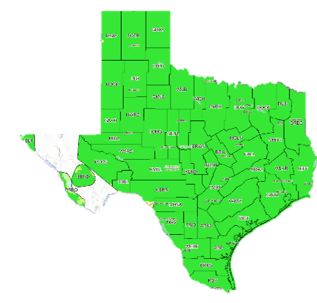
Layer 3 - Texas Multizone
Click a Layer image above to open the NGS Beta Web map for that Layer
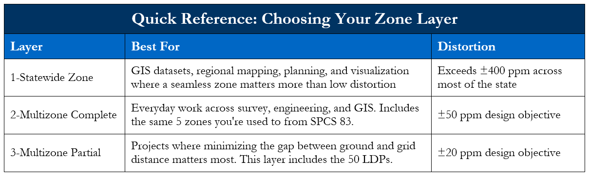
Map Projections and Zone Distortion
Now that Texas has two additional zone layers, a statewide zone and 50 low distortion projection zones, that were not present in NAD 83, it is important to understand map projections and zone distortion to best choose the zone that fits your project's specific needs.
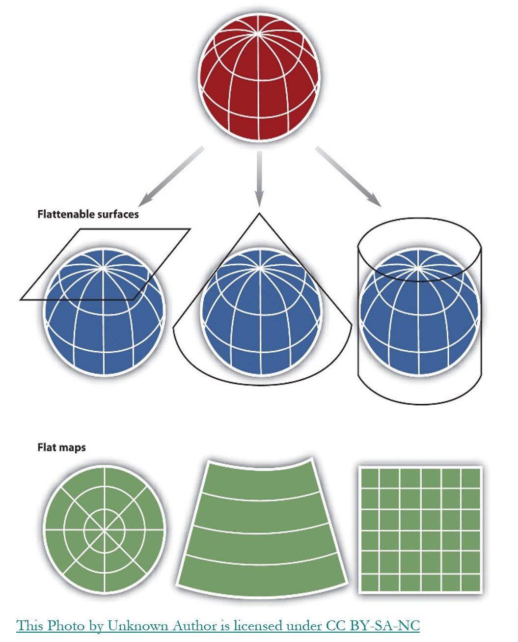
Figure 1 - Common Map Projections
The earth is curved. The state plane coordinate system zones that surveyors, engineers, and GIS professionals use every day come from map projections. A map projection is the mathematical method that takes a location on that curved surface and represents it on a flat grid, so that positions can be expressed as simple x and y coordinates instead of latitude and longitude on a sphere. See Figure 1 for a graphical representation of common map projections.
That conversion cannot be done perfectly. Any time you flatten something curved, some part of it must stretch or compress to fit. Every map projection ever created makes this same tradeoff somewhere. The differences between projections, and between the different zones within SPCS2022, come down to where that stretch happens and how much of it there is.
Zone distortion is expressed in parts per million (ppm), a way of quantifying the difference between a grid distance and the actual ground distance. One ppm means one unit of error for every million units measured. At construction and survey tolerances, it is easier to picture that same ratio scaled down to feet per mile, which is how the examples below are expressed.
At 400 ppm, a one-mile line carries about 2.1 feet of built-in distortion, before any instrument or adjustment error. At 50 ppm, that same mile carries about 3 inches, or roughly 0.26 feet, of distortion. At 20 ppm, it drops to about 1.3 inches, or roughly 0.11 feet.
So, how do you choose what is best for your project? The real question is not whether distortion exists, it's whether it matters for what your project needs. Texas offers three zone layers, each built around a different point on that tradeoff. The rest of this guide walks through each one.
Layer 1: Statewide Zone
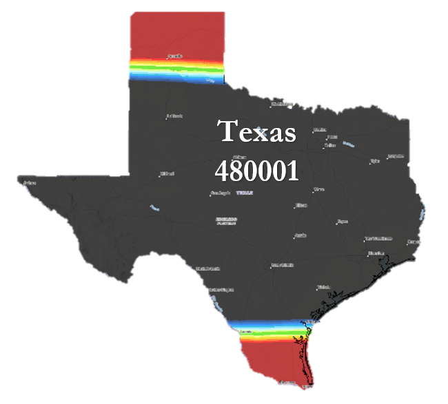
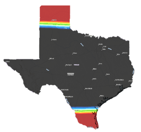
This is a new feature in SPCS2022. Every state and U.S. territory receives one Statewide Zone, designed by NGS. NGS included this zone specifically to give each state a single, seamless coordinate system that covers its entire area without the complexity of switching between multiple zones. For Texas, that means one zone, Zone Code 480001, that spans the whole state under a single Lambert Conformal Conic projection.
The Statewide Zone isn't designed for precision. Because of Texas's size, distortion under this zone exceeds ±400 ppm across most of the state, far looser than the ±50 ppm of the five-zone layer or the ±20 ppm design objective of the LDP zones. As covered above, that translates to roughly 2.1 feet of built-in distortion per mile, well beyond what any ground-based measurement work can tolerate.
Its value comes from consistency, not accuracy: having one coordinate system that applies uniformly across all of Texas, with no zone boundaries to manage or reconcile.
That tradeoff makes the Statewide Zone genuinely useful for a wide range of work that has nothing to do with ground-level accuracy. A few examples: a state agency building a public-facing dashboard of infrastructure assets across all 254 counties, a university research project mapping wildlife habitat corridors statewide, an emergency management office coordinating disaster response resources across multiple regions, or a planning department producing a statewide land use or transportation map. In each of these cases, the value comes from every feature living in one unbroken coordinate system, not from any single point being accurate to the inch.
This zone is not appropriate for survey-grade work. Given its high distortion, it should not be used for boundary surveys, construction staking, or any project where positional accuracy on the ground matters. For that kind of work, the five-zone layer or an LDP zone will serve you far better.
For projects where a seamless coordinate system is desired from planning through construction, make that decision early: choose either the five-zone layer or an LDP zone before work begins. Switching zones partway through a project can cause serious misalignment problems and added costs during design and/or construction. Picking the best zone from project initiation saves time and money through the project's lifecycle.
Layer 2: Multizone Complete
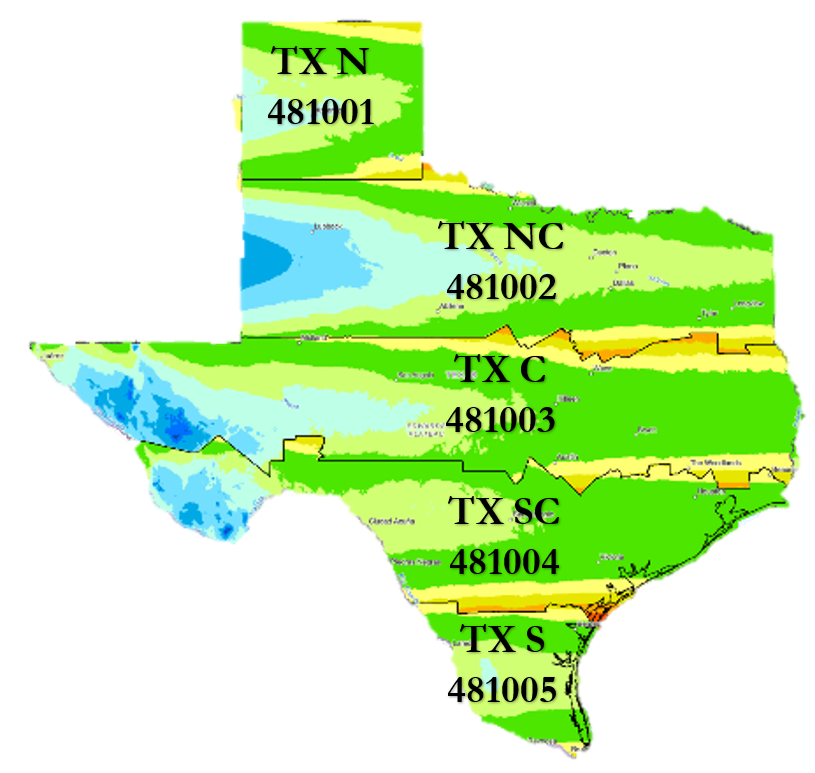
Texas's familiar five-zone layer isn't going away.
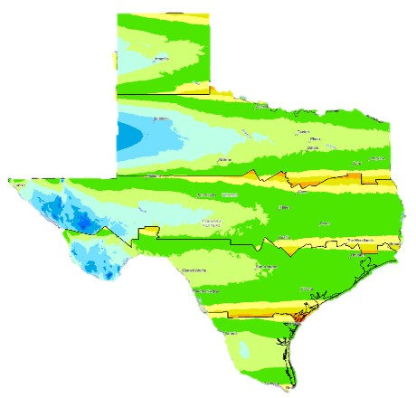
Under SPCS2022, all five zones you've used your entire career are still here: Texas North, Texas North Central, Texas Central, Texas South Central, and Texas South.
These zones have been the backbone of Texas surveying and engineering for decades. Like the Statewide Zone, the five-zone layer's SPCS2022 parameters were designed by NGS.
What Stays the Same
Zone Names: Identical to names in NAD 83
General Boundaries: Each zone covers roughly the same geographic area
Projection Family: Lambert Conformal Conic
What’s Different
Zone Codes: Each zone has a new code, however, the numbers correspond to the existing NAD 83 codes (for example, Texas North's 4201 becomes 481001)
The datum underneath them: each zone is now referenced to NATRF2022 instead of NAD 83
The projection definition itself: SPCS83 zones are defined with two standard parallels of exact scale (for example, Texas North at 34°39' and 36°11'). SPCS2022's five-zone layer instead uses a single-parallel Lambert Conformal Conic definition, with scale controlled by a projection origin scale factor rather than two exact-scale parallels
The design parameters: NAD 83 was designed at 100 ppm to minimize distortion at the ellipsoid. SPCS2022 is designed at 50 ppm to minimize distortion at the topographic surface.
The false coordinate values: every zone's false northing and easting has changed to a new, distinct value. The comparison below shows just how different these values are between the two systems.

The design objective for this layer is ±50 ppm, a real improvement over the Statewide Zone's ±400 ppm and tighter than the roughly 1:10,000 (100 ppm) standard the legacy SPCS 83 zones were designed around, translating to about 3 inches of built-in distortion per mile. The shift from two standard parallels to a single parallel with an origin scale factor is mathematically equivalent, a simpler way to define the same projection, not a change in performance. In addition, the new zones were designed to minimize distortion at the topographic surface not the ellipsoid. These zones my look the same, but thanks to improved design parameters, they will perform better than their NAD 83 counterparts.
The balance of familiarity and accuracy makes the five-zone layer the right fit for a wide range of work. In NAD 83, these zones are the only option, used for everything from GIS visualization to survey-grade mapping and infrastructure projects. Modernizing the national reference frames is also a chance to reflect the accuracy achievable with today's methods and technology, which is why two additional zone layers are being added: options that fit today's workflows, rather than asking one zone layer to serve every purpose.
Because of Texas's size, the five-zone layer's zones cover large geographic areas, which is exactly what drives the ±50 ppm distortion described above: a coordinate accurate at the zone level still needs correcting to be accurate at a specific project's scale. Survey-grade work closes that gap either with a published county-wide surface adjustment factor, or, especially before SPCS2022 offered other options, through a project-specific localization or calibration to project control, often used to minimize distortion on longer corridor projects. Localization works, but it comes at a cost: it's typically a one-off transformation living only in that project's files, with no standardized, published definition behind it. If that documentation is lost or separated from the data, the coordinates become effectively unrecoverable to any official system.
This is a primary reason LDP zones are being added to SPCS2022: a published, standardized, NGS-approved definition that solves the same distortion problem without a private, project-specific fix. The next section covers LDP zones in detail.
Layer 3: Multizone Partial – LDPs
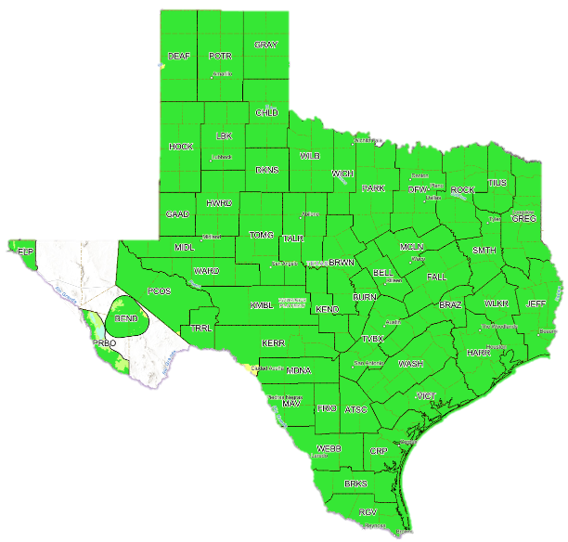
Texas has 50 Low Distortion Projection (LDP) zones under SPCS2022, designed by Texas stakeholders, led by TxDOT, and approved by NGS. LDPs are also a new feature in SPCS2022: there's no SPCS 83 predecessor to compare them to.
Why They Exist
Texas designed its LDP zones around populated and project areas. Design of this multizone partial layer is optional for each state, and as the name suggests, it isn't intended to fully cover a state's area the way the statewide or five-zone layers do.
An LDP is a coordinate zone designed so that grid distances match ground distances as closely as possible, ideally within ±20 ppm, tighter than the five-zone layer's ±50 ppm and far tighter than the Statewide Zone's ±400 ppm. The goal is to shrink or eliminate the gap between what you measure on the ground and what the coordinates say, so you can largely skip the combined scale factor. LDP zones use a mix of projection types, Transverse Mercator, Lambert Conformal Conic, and Oblique Mercator, whichever best fits the local geometry of each zone.
Benefits
Minimal distortion, grid distances closely match ground distances
LDP boundaries generally follow county lines, making them easy to identify, with a small number of exceptions explained below
Improved alignment between project phases
Simplified field to office workflows
Supports statewide consistency across projects
Notable Exceptions
Every state is allowed one complete-coverage zone layer and one partial-coverage zone layer. Since Texas kept its five-zone layer as the complete-coverage option, the LDP layer could not also cover the entire state, which is why West Texas has gaps in LDP coverage. Stakeholders placed those gaps in the Trans-Pecos region specifically, given its mountainous terrain and low population density.
Within that region, a few zones depart from county lines by design. The Big Bend LDP, covering Fort Davis, Marfa, and Alpine, does not follow county boundaries, and neither does the Presidio border LDP.
Another exception is in Harris County. The Harris LDP boundary was drawn at the Galveston Bay entrance channel rather than following the Galveston County line, since splitting the zone there, rather than at the county boundary, better minimized distortion given the zone's shape and projection.
Helpful Tip: Zone Buffers
Each LDP includes a 25-mile buffer extending beyond its official boundary, so a project just outside a zone's nominal edge may still perform well within it. This can also work in reverse: in Kerr County, the southern tip shows higher distortion under the Kerr LDP, but a project in that area may see better performance using the neighboring MDNA zone instead, even though it falls outside MDNA's official boundary. Check both the zone you'd expect to use and any bordering zones before assuming the nominal boundary is your only option.
Cautions
Minimal distortion does not mean no distortion, understand the actual tolerance for your project
Elevation differences still matter and still affect your results, analyze specific project elevation relief
Mixing datasets from different zones without proper transformation can cause misalignment, metadata is your best friend
It's easy to confuse a five-zone coordinate with an LDP coordinate depending on where your project is located, label your zone clearly (for example, the Big Bend LDP coordinates may get confused with the Texas Central Zone coordinates)
Practical Takeaways
Using LDPs or any zone in SPCS2022 is a business-driven decision. Knowing what your clients use, or plan to use, can help you prepare before a project lands on your desk. TxDOT work is a clear example: if you do TxDOT projects, you'll likely be working in LDPs, so it's worth getting familiar with them now rather than waiting until a project requires it. The same logic applies beyond TxDOT: any client, agency, or firm working on infrastructure, utilities, or development projects in a populated area is increasingly likely to expect LDP coordinates.
The business case isn't limited to firms already working in state plane coordinates. Plenty of practices run largely on assumed coordinates, doing lot and block surveys with no real tie to a statewide system, and some agencies are still using NAD 27, a defined Texas Official Coordinate System. There is nothing wrong with that, and SPCS2022 does not need to change or alter your workflow. It is worth considering, though: there is real value in adopting SPCS2022. It means your company's data across every project lives in one standardized system instead of a collection of disconnected local jobs, which pays off the moment any of that data needs to be combined, compared, or handed off, whether that's years later, to a client, to another firm, or to a future owner when you sell your business.
LDPs add a second layer of value on top of that. Because grid and ground distances match so closely, users of geospatial data largely stop needing to think about surface adjustment factors at all, a common source of confusion on projects. Removing that step doesn't just reduce error, it reduces the number of places a project can go wrong in the first place.
Many clients haven't heard this transition is coming at all, which means they haven't decided what they want yet, and won't know to ask. That's an opportunity, not a gap to wait out. Raising the topic early, before it's forced by a project deadline, is exactly the kind of guidance that makes you your client's trusted advisor through this transition rather than someone reacting to it alongside them. If a client has questions you can't answer, or wants a deeper briefing, TSRC is available to help. Contact TSRC.