
GELS CTE Program for High School Students

The Geospatial Engineering and Land Surveying (GELS) Career and Technical Education (CTE) Program is a high school pathway designed to introduce students to the high-paying, high-demand profession of Geomatics and Land Surveying through structured, licensure-aligned instruction.
Students develop foundational competencies in measurement science, boundary principles, mapping, and field data collection using industry-standard surveying instruments and geospatial technologies. The program is intentionally sequenced to align with postsecondary coursework, industry-based certifications, and Surveyor-in-Training eligibility requirements, creating a clear education-to-licensure pipeline.
| Geospatial Engineering and Land Surveying (GELS) CTE Pathway | |
| Grade 9 | |
| Principles of Applied Engineering | |
| Grade 10 | |
GISC 1336Digital Drafting and Design — An introduction to graphic and drafting principles and practices in surveying and mapping science. This course includes the development of the basic drafting skills needed to produce surveying plats and graphical presentations. The elements of descriptive geometry are addressed. A major component of the course is an introduction to the fundamentals of computer-aided drafting (CAD) and design. Tap the course code again to close.Digital Drafting and Design (3 Credit Hours) |
GISC 1470Geospatial Systems I — Introduction to geographic information systems (GIS) and its theoretical foundations. Topics covered include vector and raster data models, acquisition and manipulation of data, cartography, current topics, data quality, and basic spatial analysis. Principles and uses of GIS software also covered. Fall and Spring. Tap the course code again to close.Geospatial Systems I (4 Credit Hours) |
| Summer Bridge | |
| GAUS 2071 - Fundamentals of UAS (3 Credit Hours) | |
| Grade 11 | |
GISC 2301Geospatial Systems II — An intermediate level course in the concepts and applications of geographic information systems (GIS). Topics covered include spatial database design and management, raster analysis, terrain mapping, analysis, and applications. Tap the course code again to close.Geospatial Systems II (4 Credit Hours) |
GISC 3421Visualization for GIS — Basic elements of thematic cartography, cartographic theory, and cartographic projections. Integration of cartographic principles with GIS visualization. Principles of map design with GIS data. Spring. Tap the course code again to close.Visualization for GIS (4 Credit Hours) |
| Optional Summer Bridge | |
MATH 1316*Trigonometry — Trigonometric functions, identities, equations involving trigonometric functions, solutions of right and oblique triangles. Tap the course code again to close.Trigonometry* (3 Credit Hours) |
|
| Grade 12 | |
GISC 2470Geospatial Plane Measurement I — Historical introduction to field measurement and mapping; distance measurement using electronic distance meters; calibration and reduction. Leveling instruments; principles, construction, testing and adjustment; ancillary equipment. Optical and electronic theodolites. Traverse computations and adjustment. Coordinate systems. Map projections. MATH 1316 or placement in a course beyond or at a higher level than MATH 1316. Tap the course code again to close.Geospatial Plane Measurement I (4 Credit Hours) * Requires Trigonometry |
GISC 3412Geospatial Plane Measurement II — Principles and reduction of observations and errors in spatial measurement. Techniques of horizontal and vertical angle measurement for precise positioning. Trigonometric heighting and vertical staff tacheometry. Setting out of structures. Design and computation of horizontal and vertical curves. Tap the course code again to close.Geospatial Plane Measurement II (4 Credit Hours) |
Course pathway layout presented by grade with optional summer bridge courses.
For school districts, GELS offers a replicable framework for addressing workforce shortages in the surveying profession; for students, it provides an early, practical entry point into a technically rigorous career with defined advancement pathways toward professional registration.
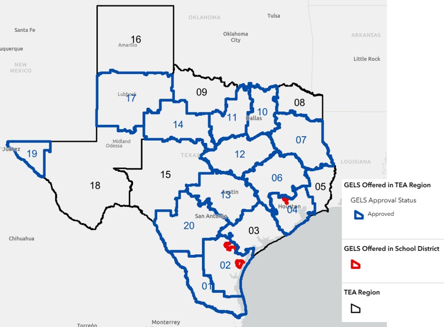
GELS CTE Program Texas Regional Approval Map:
The GELS CTE TEA Fact Sheet can be found under the Engineering section (bottom of page) on the TEA website. See the link below for details.
How to enroll
Interested in enrolling or establishing the GELS CTE program at your high school? Visit our Islander Academy website to learn more.