University Beach - A Brief History

Casting one’s gaze across its 1,200 feet of coarse quarry sand, it’s easy to forget that University Beach was once like the rest of the Ward Island shoreline on either side – defined by discarded concrete and construction materials – until its restoration was complete in 2001 after nearly seven years of research and planning as part of one graduate student’s thesis.

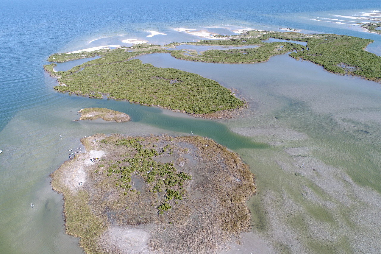
The history of University Beach, which sits adjacent to Texas A&M University-Corpus Christi, is a complex one, according to Deidre D. Williams, Conrad Blucher Institute for Surveying and Science Coastal Research Scientist. A narrow beach between 50 and 100 feet wide was visible in aerial photographs from 1938 before eroding as a result of shoreline stabilization efforts to support the eventual commissioning of Naval Air Station Corpus Christi in 1941.

“There was all of this exposed sand, and it was mobile. So when the shoreline was stabilized and elevated by placing riprap and rubble along the shoreline – something that is common in bayside communities all along the Texas coast – what we discovered is that a beach couldn’t naturally accrete (build) anymore,” Williams said.

It was Williams who heeded the call to restore the beach. She started working at the Blucher Institute in the late ‘90s as an undergraduate who wanted to gain research experience.

“Initially, I thought I wanted to work with aquifers, but I found that it was even more interesting to study coastal environments, so this led me to studying beaches and inlet systems,” Williams said.

Williams said the Blucher Institute began studying the morphology of the near-shore sand bar system as an academic exercise in the early ‘90s. CBI’s-then Director Dr. Nicholas Kraus shared details about the beach’s history with then-University President Dr. Robert Furgason and then-Vice President Ray Hays; both University leaders expressed enthusiasm for a feasibility and functional design project to restore the beach and studies soon followed.

To help pay for the project’s studies and ultimate construction, the Island University partnered with the Texas General Land Office (TGLO).

“As part of my thesis, we designed the beach, we initiated the permitting for the beach, we conducted modeling to see if it was even possible to restore the beach and if so, what structures would be required,” Williams said. “We looked at all iterations of what the beach could look like, including sand only – ultimately it was determined that structures would be most the most effective option to stabilize the beach. Then we had to determine how many structures and how large they would need be to secure the beach long term.”

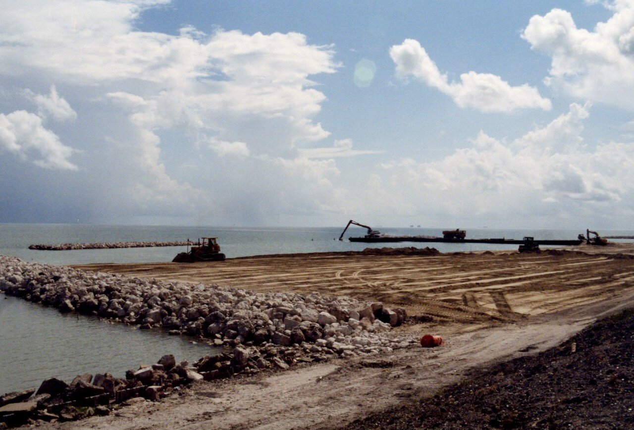
The design Williams came up with is a concept based on the fewest number of structures required to maintain the beach: two terminal groins, or shore perpendicular structures at each end, and three detached breakwaters (shore parallel structures). Working closely with CBI was the Corpus Christi firm Shiner Moseley and Associates. The firm developed the final engineering specifications from the functional design. After five months of construction, which included the transportation of sand from an old Nueces River tributary, University Beach was completed in August 2001. The overall project cost was $1.5 million and was made possible by the cooperation and support of the Island University, the Blucher Institute, the City of Corpus Christi and the TGLO.

Following the beach’s restoration, Williams published her thesis, “A Recreational Beach Fill for Texas A&M University-Corpus Christi: Coastal Processes and Functional Design” in 2002. She is grateful to University administration for supporting her and providing this opportunity to fuel her passion for stewardship of our beaches. Williams now leads two long-term monitoring programs related to the management of beaches locally and all along the Texas coast (Coastal Erosion Planning and Response Act (CEPRA), Beach Monitoring Program) as well as the Packery Channel Monitoring Program.

The issue of renourishment was a challenging one to contend with. Even with the containment structures, Williams theorized the beach would need to be renourished with additional sand after a decade. In fact, the design has proven to be far more effective than the modeling effort and analysis predicted.

Deidre D. Williams, Conrad Blucher Institute for Surveying and Science Coastal Research Scientist

Deidre D. Williams, Conrad Blucher Institute for Surveying and Science Coastal Research Scientist

“We’re going on 18 years and we have done no maintenance, which would be an expensive endeavor due to transportation costs; this is a self-sustaining project due to the cellular design,” Williams said. “This is very unique in the world of beaches.”

Nesting Shorebird Season: Take Caution When Visiting the University Beach

CORPUS CHRISTI, Texas – Shorebird nesting season, which is from early April to early August, is here and birds have begun to lay their eggs on University Beach at Texas A&M University-Corpus Christi, which is located across Ocean Drive from the Performing Arts Center and along Corpus Christi Bay. Nests of Least Terns, a Wilson Plover, and a Killdeer have already been identified along the central section of the beach, and fencing and signage has been placed around nesting sites by volunteers from the Conrad Blucher Institute (CBI) at Texas A&M-Corpus Christi, U.S. Fish & Wildlife Service, and the Coastal Bend Audubon Society.

“The most important thing to remember is that avoiding the nesting area is critical for a successful nesting season,” said Deidre Williams, Coastal Research Scientist at CBI. “Human and animal activity can frighten the birds and cause them to abandon their nest, leaving the eggs or baby birds exposed to predators and the heat.”

When at University Beach, visitors must take extra care to keep clear of the fenced areas, obey the warning signs, and stay at least 150 feet away from shorebirds. Additionally, not all nests are located within the fenced areas and beachgoers need to pay special attention to their surroundings as the nests blend in with the sandy surface and are easily missed. For more information on Federally protected shorebirds, visit the U.S. Fish & Wildlife Service web site

According to the Coastal Bend Bays & Estuaries Program (CBBEP) website, there are several other ways visitors can avoid disturbing the shorebirds:

  • Keep dogs on a leash and away from areas where birds may be nesting (city leash law)

  • Properly dispose of trash to keep scavengers away

  • Never abandon fishing line or other gear, and remove it if you find it

  • Do not fly traditional kites or kites for kitesurfing near areas where birds may be nesting

  • When birds are aggravated, you are too close

  • Leave the area if shorebirds fly at you

Those interested in bird-watching during nesting season can observe from the bluff along Ocean Drive since it offers an ideal elevated view of the birds and is less invasive than walking on the beach. BUT if the birds take flight that means you need to move away.

“With the help of the Islander community, we hope that the Least Terns and other protected shorebirds will have another successful nesting season resulting in the young reaching fledgling status,” said Williams, whose thesis project was the functional design of the University Beach.

ADDITIONAL INFORMATION:

Nesting is usually initiated in early April and concludes by end of July. Eggs are incubated for three weeks, and young take approximately three to four weeks before they are capable of flight.  The extent of nesting season depends on whether the first nesting attempts are successful or if birds have to re-nest after a failure or destroyed nest.

To learn more about the CBI and the University Beach, visit https://cbi.tamucc.edu/CHRGIS/University-Beach/.

Conrad Blucher Institute Welcomes Dr. Philippe Tissot as Interim Director

2018_1220-DrGaryJeffress-Event-9450-X2.jpg

CORPUS CHRISTI, Texas – With a new year comes the beginning of a fresh chapter for Texas A&M University-Corpus Christi’s Conrad Blucher Institute (CBI). Dr. Philippe Tissot, who has served as CBI’s associate director since 2011, took on a new role as interim director on Tuesday, Jan. 1. As an Islander and a CBI researcher for nearly 20 years, Tissot strives to continue CBI’s positive impact and its close relationship with the community while pushing CBI to be an industry leader in geospatial science research and engineering.

When Tissot, who grew up in the mountains of Switzerland, first arrived in Texas to pursue a doctoral degree in nuclear engineering from Texas A&M University in 1988, he had no idea how much he would come to love the city of Corpus Christi. After vacationing with his wife at Padre Island National Seashore, he became infatuated with the Coastal Bend’s natural beauty and wide-open beaches.

Ten years later, Tissot found his home at the Island University’s CBI. With a family legacy of more than 100 years, CBI was dedicated in 1987 to foster surveying education and research. Since then, the institute has joined the United Nations-Global Geospatial Management (UN-GGIM) Academic Network, collaborated with leading area organizations like the U.S. Army Corps of Engineers, the Texas General Land Office, and the Port of Corpus Christi, as well as cultivated research with positive ecological impact, among a plethora of achievements. 

“It’s been great working for an institute that has deep roots in our city,” shared Tissot, whose current research focuses on coastal modeling, including relative sea level rise and its impact. “We are a good team that’s been together for a long time.”

In the early 2000s, Tissot, along with his colleagues, began using artificial intelligence (AI) to analyze environmental data sets. By the mid-2000s, they had implemented AI-based operational models to analyze water levels, temperatures, and currents.

With these technologies, Tissot and other CBI experts can make predictions that allow agencies like the Texas Parks and Wildlife Department, the National Park Service, and the National Weather Service as well as volunteers to mobilize and prepare for emergencies, such as flooding or sea turtle cold-stunning events. Tissot has contributed broadly to the field and has served as the chair of the American Meteorological Society Committee on the AI Applications to Environmental Science for the past two years.

At CBI, scientists have advanced methods to analyze massive modern surveying technology sets by incorporating AI techniques into these analyses.

“We use AI for a lot of the data that comes from lidar and unmanned aerial systems (UAS),” said Tissot. “It’s tens-of-millions if not hundreds-of-millions of data points, so there’s a lot of power in using AI to cluster the data and automatically identify different parts of an image or rectify parts of the data set to obtain more accurate 3-D maps.”

Since Tissot’s first day at CBI, surveying research has quickly increased with technological advancements. Exciting new research is performed at CBI using larger environmental data sets, and technologies like lidar, which is a surveying method that uses light technology, UAS, and rapid indoor positioning systems, which were not available 20 years ago. His colleagues, Dr. Michael Starek, associate professor of geospatial systems engineering (GIS), and Dr. Tianxing Chu, assistant professor of GIS, are paving the way with their students in using these new technologies. 

During his 12-18-month period as interim director, some of Tissot’s initiatives include building a strong relationship with private businesses, reinventing information technology at CBI, helping new faculty to get a good start, partnering with international collaborations, and renewed efforts in recruiting. He will be assisted by Gina Concannon, interim associate director, and James Rizzo, assistant director of operations. 

His predecessor, Dr. Gary Jeffress, professor of geographic information science at Texas A&M-Corpus Christi, will continue leading efforts in CBI’s collaboration with UN-GGIM.

“CBI activities are at the cutting edge of emerging technologies and with a substantial overlap with private-sector needs,” said Tissot. “Over the past 10 years, Dr. Jeffress and I, in collaboration with Dean Frank Pezold and our institute colleagues, have worked to create a very integrated unit – with faculty, researchers, staff, and students all working seamlessly. We look forward to continuing along this path with our students and partners.”

Island University Honors Dean Emerita at Alumni Shrimp Boil

CORPUS CHRISTI, Texas – From a relaxing boat ride to the Laguna Madre Field Station to a feast of savory Cajun-style shrimp, Islander alumni, faculty, and staff enjoyed an idyllic afternoon of science, food, and sunshine as part of the 2018 Alumni Shrimp Boil, hosted by the College of Science and Engineering at Texas A&M University-Corpus Christi on Oct. 27. Guests gathered to reconnect and celebrate Dr. Diana Ida Sanchez Marinez, COSE dean emerita and a founding member of the Society for Advancement of Chicanos/Hispanics and Native Americans in Science (SACNAS).

Each year, the COSE Alumni Shrimp Boil recognizes a deserving faculty member or alumnus who has contributed greatly to the college. During the celebration, Marinez was honored with an award to symbolize her legacy, and her name was engraved on a brass plate, which will be hung in the dean’s suite on campus.

“Today’s honoree was my predecessor. When I arrived in 2006, there was already a foundation and a culture of research in place that had been growing during Dr. Marinez’s time,” said Dr. Frank Pezold, current COSE dean and professor. “She made a difference and worked diligently to set the stage for where we are as a college today.”

Marinez came to Texas A&M-Corpus Christi in 1994, when the COSE was originally called the College of Science and Technology. Upon her arrival, Marinez had the vision to foster competitive research of all levels at the Island University. At the time, the Center for Coastal Studies was the main hub of research for the college and she empowered like-minded faculty to develop research, improve the curriculum, and provide undergraduate students with more hands-on experience and exposure to other great scientists in the college.

“I had the opportunity to build and develop a vision for a strong science program in South Texas,” shared Marinez. “That’s not a privilege many deans have, and I didn’t do it alone – I did it with a dedicated faculty and staff who wanted to bring our vision to life.”   

Marinez’s educational leadership extends beyond Texas. She was an advisor for the National Kellogg Fellowship Program from 1993 to 1996 and has served on committees and panels for the National Academy of Sciences, National Institutes of Health, National Science Foundation, and American Association for the Advancement for Science. She is also a board member for the South Texas Institute for the Arts.

After 13 years working at the University, Marinez is now enjoying her retirement. She stays active in her community of Lansing, Michigan and monitors immigrant issues – and of course, she still mentors students like Islander alumnus Matthew Cruz, who benefited greatly from the research opportunities she created.

“I’d like to say thank you to Dr. Marinez for giving Mexican-Americans the opportunity to thrive in science,” shared Matthew Cruz, `16. “SACNAS plays a huge part in our education, and being able to meet other scientists, who come from similar backgrounds, inspired me to pursue a master’s degree.”  

New PORTS in Corpus Christi and Toledo Bring Safety, Economic Benefit to Marine Navigation Community

Published October 2, 2018

Crew from the Conrad Blucher Institute for Surveying and Science install a current meter on a U.S. Coast Guard Aids to Navigation buoy in Corpus Christi. (Credit from CBI, Texas A&M University-Corpus Christi) .

Crew from the Conrad Blucher Institute for Surveying and Science install a current meter on a U.S. Coast Guard Aids to Navigation buoy in Corpus Christi. (Credit from CBI, Texas A&M University-Corpus Christi) .

This summer, NOAA established two new Physical Oceanographic Real-Time Systems (PORTS®) that service seaports in Corpus Christi, Texas and Toledo, Ohio. Both systems contain current meters and water level sensors that provide real-time data to pilots navigating large ships through narrow waterways. This information provides considerable navigation safety and economic benefits for the seaports and surrounding communities.

NOAA now has 33 PORTS covering the top 20 seaports (by tonnage), and 76 seaports overall, in the United States.

PORTS is a successful public-private partnership that reduces ship accidents by more than 50 percent, increases the amount of cargo ships can carry, reduces transit delays for commercial traffic, enhances recreational activities, and improves hazardous spill response. Systems around the country provide vessel operators with key environmental parameters in real time, including water levels, currents, waves, salinity, bridge clearance (air gap), wind speed and direction, air and water temperature and visibility..

In Corpus Christi, strong currents in the transit into Corpus Christi Bay make it difficult for vessels to navigate. A majority of the vessels coming into the Port of Corpus Christi are carrying hazardous materials, such as liquid natural gas and other chemicals. The port authority requested a PORTS with real-time current meters to provide pilots with information that can help them safely reach and depart the seaport.

In Toledo, ships using a current meter that was put initially put in as a pilot project, will be able to continue safely traveling the Maumee River with its transition into the PORTS program as a new PORTS in that area. A number of industries along the Maumee River are completely reliant on maritime transportation for the delivery of their bulk materials including cement, grain, petroleum, and iron. The Maumee River Channel averages 500 feet in width but narrows to as little as 200 feet in portions of the navigable channel. NOAA has partnered with the Toledo-Lucas County Port Authority to maintain the meter.

The current meter measures horizontal current profiles and includes a water temperature sensor. It was built to withstand harsh winters and ice in that area.

“The current meter is essential to navigators for making good decisions. Toledo is probably the most dynamic port on the Great Lakes when it comes to rapidly changing currents, water levels and weather. We are very happy to finally have the PORTS system in place where we have one source for all the real time data that we need,” said Captain George Haynes, a local pilot in Toledo.

Both PORTS include water level and meteorological information from NOAA’s National Water Level Observation Network, a system of 210 permanent real-time water level stations on U.S. coasts and in the Great Lakes. Knowing the currents, water levels, and winds can enable shippers to optimize cargo loads so that vessel captains and pilots are using every inch of available channel depth safely, maximizing profits and efficiency. Just one additional inch of usable draft can translate into millions of dollars of additional cargo per vessel transit.

View Original NOAA Article

Conrad Blucher Institute Tackles Global Issues with United Nations

CORPUS CHRISTI, Texas – It’s not uncommon to see sorrowful TV advertisements showing glimpses of children from developing countries suffering from malnutrition and food insecurity. But all over the world, hunger is just one of many major issues affecting children and adults – even in our own neighborhoods.

“A couple of years ago, the United Nations (U.N.) came up with 17 sustainable development goals such as no poverty, zero hunger, quality education, and gender equality,” explained Dr. Gary Jeffress, professor of geographic information science and director of the Conrad Blucher Institute for Surveying and Science at Texas A&M University-Corpus Christi. “They are all very noble goals, many of which affect us right here in the Coastal Bend. For example, not everyone in South Texas has access to clean water and sanitation, affordable energy, or access to education.”

To help find resolutions, Jeffress, along with Dr. Michael Starek, associate professor of geospatial systems engineering and the director of the Measurement Analytics Lab (MANTIS), attended a forum hosted by the United Nations Committee of Experts on Global Geospatial Information Management (UN-GGIM) Academic Network from July 30 to Aug. 3.

The international partnership aims to merge every country’s census data with mapping technology in a Geographic Information System (GIS) environment. With this map, international experts and experts from CBI can pinpoint precise areas in need of economic, social, and environmental aid.

“We’re collecting data for a purpose,” said Jeffress. “We can take existing knowledge, like census data, and apply it in a practical sense to impact the lives of many. It’s an opportunity to expand projects we’ve done locally, such as locating medically underserved areas or identifying crop diseases, on a global scale.”

While every country collects census data that is vital to addressing the U.N.’s key global issues, this data is not easily accessible for world leaders to use.

That’s where CBI experts come in.

Starek uses drones to revolutionize geospatial-aided decision making for addressing pressing problems of global concern in areas of coastal resiliency, sustainable resource development, and crop management to promote food equality and world-wide "zero-hunger." Additionally, Dr. Lucy Huang, associate professor of geographic information science, uses GIS techniques to analyze health issues, such as health care access, that can be used to meet the United Nations’ goal of “good health and well-being” for all.

Last year, the CBI was one of three of the nation’s universities, including Harvard University and the University of Maine, to join the UN-GGIM Academic Network to strategically create solutions for 17 sustainable goals using GIS systems by 2030. The CBI was chosen to join the worldwide network of academics and scientists based on their established track record in GIS and their ability to positively impact the UN-GGIM Academic Network. Future goals include acquiring grants to attract incoming graduate and doctoral students to develop new GIS programs to help solve the world’s issues while working on their dissertations.

Conrad Blucher Institute and Bell Library Celebrate 100K Historical Documents Cataloged

CORPUS CHRISTI, Texas – When Texas was young and the land still uncharted, surveyors were called upon to map the wild frontiers – surveyors like Baron Felix von Blucher, the first in a long line of Bluchers who mapped the original land boundaries of Corpus Christi and South Texas. His grandson, Conrad Blucher, was the last of three generations of Blucher family surveyors. Their work generated 400 field books and thousands of maps – a legacy spanning more than 100 years of surveying in South Texas.

The public now has online access to these historical and legally significant documents, the earliest of which are the Blucher Family Papers, thanks to a partnership between Texas A&M University-Corpus Christi’s Special Collections and Archives Department at the Mary and Jeff Bell Library and the Conrad Blucher Institute (CBI) for Surveying and Science.

“This project is so much more than a partnership, it’s a blending of professions,” shared Bryan Gillis, Spatial {Query} Lab Coordinator at CBI and survey digitization project lead. “I am most proud of how we have torn down so many walls, literally and figuratively, to accomplish some great interdisciplinary work.”

To make the maps more accessible to students and local surveyors, Seneca Holland, former Texas A&M-Corpus Christi faculty and Dr. Thomas Kreneck, former associate director of special collections, had the idea to start the project seven years ago. For the last four years, Gillis and his team of student workers – in collaboration with the Special Collections staff and students – have accelerated the pace of work thanks to external grant funding.

“I picked up this project in the last ten months and my experience has been mind-blowing,” said Shebly Gonzales, library specialist II and Island University graduate student. “It’s important that our generation understands the significance of history, so we’re making sure it’s properly preserved and readily available for the future.”

During an event on July 13, professional surveyors from across the state of Texas, as well as local community members, joined CBI and library staff to celebrate the cataloging of the 100,000th document, a map. After a brief introduction from project managers, Ronald E. Brister, registered professional land surveyor and original champion of the project, had the honor of ceremoniously cataloging the map. 

Guests had the chance to glimpse archived documents from 1859 to 1978. Some of the pieces included a large general index and a field book featuring an excerpt from a surveyor in the 30’s who was swarmed by “15 billion mosquitos.” Blueprints, maps and even an original sketch of Corpus Christi done by Felix von Blucher were also on display.

“We have important history in our archives, and it shouldn't’t only be accessible to a few elite people who know about it. It needs to be discoverable and available to everyone,” shared Dr. Catherine “Cate” Rudowsky, dean of Libraries at A&M University-Corpus Christi. “Ensuring equal and unbarred access to information and our history is an ultimate responsibility of libraries, and this project provides that.”

In reaching this new milestone, CBI and Special Collections have only scratched the surface. In addition to eight other surveying collections, they still have thousands of land records to make accessible but plan to expand their project to include preserving other public historical documents.

“The people of South Texas have been, and still are, susceptible to loss of their land based on whether or not original records can be produced,” explained Gillis. “Helping the public gain easy access to land information that is rightfully theirs is how I, as a member of the surveying community, hope to protect them.”

A&M-Corpus Christi Researcher helps Tackle Indoor GPS Limitations and Wins $20,000

CORPUS CHRISTI, Texas – With the use of a smartphone, loads of information ranging from funny memes to the latest news is accessible at the touch of one’s fingertips. Users can track their location on daily jogs, use GPS to utilize rideshare apps or find highly rated restaurants nearby. Every day, technology adds convenience to a person’s lifestyle, but it’s not without limitations.

Dr. Tianxing Chu, assistant research scientist at Texas A&M University-Corpus Christi’s Conrad Blucher Institute (CBI) for Surveying and Science, and researchers from Wuhan University, China, created an app to improve smartphone limitations when it comes to GPS. The research team, led by Wuhan University Professor and former CBI Endowed Chair Ruizhi Chen, participated in the National Institute of Standards and Technology (NIST) “2018 Performance Evaluation of Smartphone Localization Application Challenge (PerfLoc).” The competition took place in April, where Chu and his colleagues took first-place among a total of 152 registered teams. Their achievement was recognized with a certificate and a $20,000 check earlier this month in California.

“Imagine firefighters entering an unknown burning building. Accurately knowing their positions and that of other partners is invaluable,” said Chu. “Precisely locating people in need during emergency situations can make a huge difference when it comes to saving lives.”

An important issue, GPS often becomes blind in indoor environments, leaving public safety officials without the necessary information to rescue those in need. The primary goal of the competition was to encourage the development of the best smartphone indoor location tracking solutions. Maintaining robust location signals under demanding and varying environments improves service in times of crisis.

The app’s performance was tested in scenarios mimicking a real-world environment. As the contest judge walked through an 11-story building, the app had to consistently provide an accurate location whether it be in the basement, the stairways or in the office area. The simulated movements included walking forward, walking backward, sidestepping, taking an elevator, transporting the smartphone on a pushcart and even crawling on the floor.

While the app is not ready for public use, the research team will continue to develop a robust indoor localization solution, particularly for public safety applications such as locating emergency responders.

Valuable Water Monitoring System Destroyed by Harvey Benefits from Grant

CORPUS CHRISTI, Texas – Oyster reefs, salt marshes and a wide range of fisheries which support larger wildlife like the endangered Whooping Crane are all affected by the quality of water that flows from the San Antonio Bay system, located an hour east of Corpus Christi. Under the watchful eye of the Conrad Blucher Institute for Surveying and Science (CBI) at Texas A&M University-Corpus Christi, the San Antonio Bay system has received constant monitoring since 2004. That was until Hurricane Harvey destroyed the monitoring station last August.

“In addition to the wildlife, a healthy San Antonio Bay system also supports commercial and recreational fisheries, all of which are dependent on freshwater inflow decision making,” said Larry Lloyd, CBI research specialist II and project lead. “The total annual economic impact of recreational marine fishing in San Antonio Bay includes 206 jobs, $7.6 million in labor income, $11.6 million in value-added and $20.7 million in sales of goods and services.” 

Thanks to a $23,833 grant from The Gulf Research Program (GRP) of the National Academies of Sciences, Engineering, and Medicine, Lloyd will now be able to reestablish this valuable monitoring system. A monitoring system that provides valuable data to numerous environmental management organizations.

“Several entities utilized the data for a range of environmental management tasks including supporting freshwater inflow transportation, oil spill response, forecasting of bay conditions and environmental impact evaluations,” said Lloyd. “The data provided by this station was the foundation of important environmental management in the Coastal Bend and all along the Guadalupe River which runs throughout the Texas Hill Country.”

With this funding, Lloyd and his team plan to reinstall the station to the exact specifications as before its destruction. Once back online, the station, an 8-by-8 foot wooden platform outfitted with the latest in technology will provide water temperature, salinity, pH, dissolved oxygen and water current velocity and direction. All of the information will be available to the public in near real-time at cbi.tamucc.edu/cbi/data.

The GRP awards are the result of the second of two fast-track grant cycles for Scientific Research Disaster Recovery Grants announced last November. Four Texas A&M University-Corpus Christi researchers received grants totaling $117,725 in April during the first cycle of the GRP’s Scientific Research Disaster Recovery Grants.

*Research reported in this article was supported by the Gulf Research Program of the National Academies of Sciences, Engineering, and Medicine under award number 2000009483. The content is solely the responsibility of the authors and does not necessarily represent the official views of the Gulf Research Program or the National Academies of Sciences, Engineering, and Medicine.

Island University Professor Continues to Monitor Crucial Wetlands Post-Harvey Thanks to $41k Grant

CORPUS CHRISTI, Texas – It’s been more than nine months since Hurricane Harvey hit, but the Coastal Bend is still feeling the impact. We know about the structural, economic and environmental damage that was done, but one aspect we don’t often think about is the effect Harvey had on important research equipment and data. Dr. Michael Starek, associate professor of geospatial systems engineering at Texas A&M University-Corpus Christi, received a $41,084 grant from the National Academies of Sciences' Gulf Research Program Scientific Research Disaster Recovery Grants.

The grant will allow Starek to work with his colleagues at the University of Texas Marine Science Institute and its Mission-Aransas National Estuarine Research Reserve to repair equipment damaged during Harvey and continue research that enhances the collection methods of data needed for flood modeling, flood prediction, hurricane impact assessment and coastal resilience plans. Starek is excited to be able to continue his research now but says in the wake of the storm his research was the last thing on his mind.

“What made me feel sad was going to Rockport and Port Aransas for reconnaissance surveys right after the storm and seeing first-hand the impact Harvey made to the local community,” said Starek, who is also the director of the Measurement Analytics Lab at the Conrad Blucher Institute for Surveying and Science.

Unfortunately, Harvey caused the submersion of two of Mission-Aransas Reserve’s Surface Elevation Tables (SETs) and damaged another at a research site at Mud Island – which is just north of Port Aransas going towards San Jose Island. The funding from the grant will allow for not only a new site to be established at Copano Bay, but also for three new SETs to be installed in partnership with the Mission-Aransas Reserve. These SETs, which precisely measure the sediment gained or lost in small areas, are installed in groups of three at four strategic marsh locations in the Mission-Aransas Natural Estuarine Research Reserve. Baseline data from the SETs collected by the Mission-Aransas Reserve are being used by Starek's research team to improve the accuracy of emerging remote sensing technology such as Unmanned Aerial Vehicles and terrestrial Light Detection and Ranging. These technologies allow monitoring of the marsh surface and land cover at high spatial detail.

“This is important because, in the wetlands, a few centimeters of elevation change can make a huge difference in what vegetation is going to exist, how frequently that area will become inundated and if it is going to successfully adapt to future changes in relative sea level,” Starek said.

While wetlands bring beauty to the Coastal Bend in terms of aesthetics, they are also hugely important to our environment and biodiversity as they are located at the interface between land and sea. They act as nutrient filters and habitats for fish and birds. Another important function of wetlands is to help to dampen wave energy, flooding and storm surges.

“The wetlands are a less well-known draw to the region compared to our sandy beaches,” Starek said. “People’s appreciation for them is a big part of why they come to visit here. And it’s important to the local community because, whether they realize it or not, wetlands are a part of our daily lives.”

Currently, Starek and his team are waiting for their permits to be approved so they can install the SETs at their new site in Copano Bay. The updated data will be used to monitor how wetlands in the region are evolving and responding to future changes in sea level and recovery from Harvey and other storms.

“I’m thankful to the National Academies of Sciences,” Starek said. “This grant is helpful because we didn’t have a budget or any way to support that equipment replacement and this funding will be put to good use.”

*Research reported in this article was supported by the Gulf Research Program of the National Academies of Sciences, Engineering, and Medicine under award number 2000009314. The content is solely the responsibility of the authors and does not necessarily represent the official views of the Gulf Research Program or the National Academies of Sciences, Engineering, and Medicine.