Valuable Water Monitoring System Destroyed by Harvey Benefits from Grant

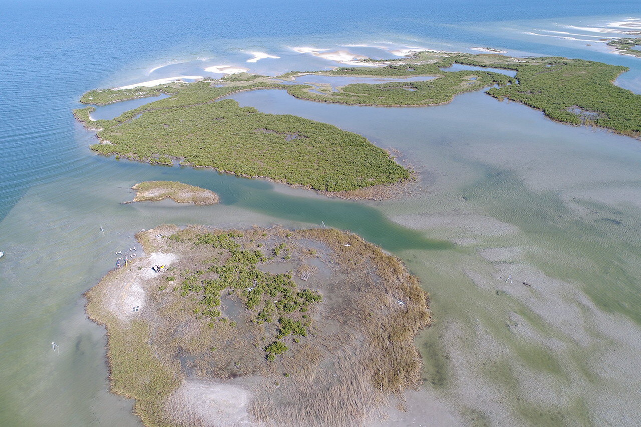
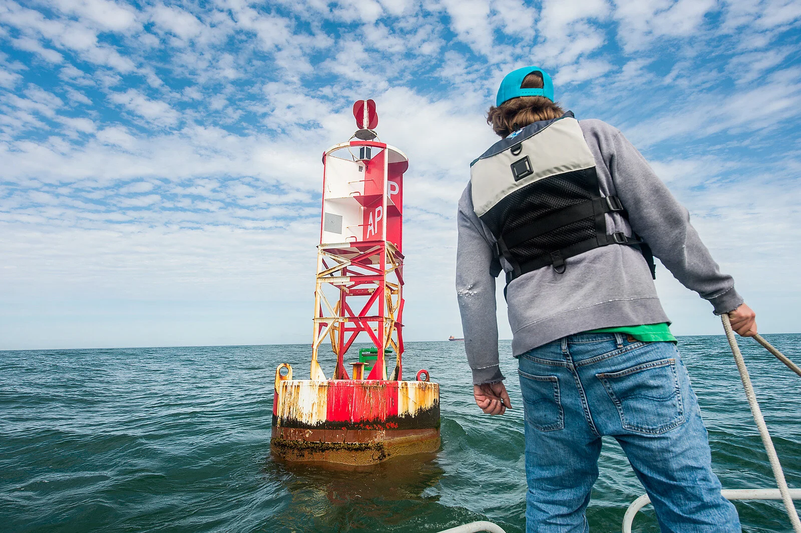
CORPUS CHRISTI, Texas – Oyster reefs, salt marshes and a wide range of fisheries which support larger wildlife like the endangered Whooping Crane are all affected by the quality of water that flows from the San Antonio Bay system, located an hour east of Corpus Christi. Under the watchful eye of the Conrad Blucher Institute for Surveying and Science (CBI) at Texas A&M University-Corpus Christi, the San Antonio Bay system has received constant monitoring since 2004. That was until Hurricane Harvey destroyed the monitoring station last August.

“In addition to the wildlife, a healthy San Antonio Bay system also supports commercial and recreational fisheries, all of which are dependent on freshwater inflow decision making,” said Larry Lloyd, CBI research specialist II and project lead. “The total annual economic impact of recreational marine fishing in San Antonio Bay includes 206 jobs, $7.6 million in labor income, $11.6 million in value-added and $20.7 million in sales of goods and services.” 

Thanks to a $23,833 grant from The Gulf Research Program (GRP) of the National Academies of Sciences, Engineering, and Medicine, Lloyd will now be able to reestablish this valuable monitoring system. A monitoring system that provides valuable data to numerous environmental management organizations.

“Several entities utilized the data for a range of environmental management tasks including supporting freshwater inflow transportation, oil spill response, forecasting of bay conditions and environmental impact evaluations,” said Lloyd. “The data provided by this station was the foundation of important environmental management in the Coastal Bend and all along the Guadalupe River which runs throughout the Texas Hill Country.”

With this funding, Lloyd and his team plan to reinstall the station to the exact specifications as before its destruction. Once back online, the station, an 8-by-8 foot wooden platform outfitted with the latest in technology will provide water temperature, salinity, pH, dissolved oxygen and water current velocity and direction. All of the information will be available to the public in near real-time on the CBI website.

The GRP awards are the result of the second of two fast-track grant cycles for Scientific Research Disaster Recovery Grants announced last November. Four Texas A&M University-Corpus Christi researchers received grants totaling $117,725 in April during the first cycle of the GRP’s Scientific Research Disaster Recovery Grants.

*Research reported in this article was supported by the Gulf Research Program of the National Academies of Sciences, Engineering, and Medicine under award number 2000009483. The content is solely the responsibility of the authors and does not necessarily represent the official views of the Gulf Research Program or the National Academies of Sciences, Engineering, and Medicine.

Island University Professor Continues to Monitor Crucial Wetlands Post-Harvey Thanks to $41k Grant

CORPUS CHRISTI, Texas – It’s been more than nine months since Hurricane Harvey hit, but the Coastal Bend is still feeling the impact. We know about the structural, economic and environmental damage that was done, but one aspect we don’t often think about is the effect Harvey had on important research equipment and data. Dr. Michael Starek, associate professor of geospatial systems engineering at Texas A&M University-Corpus Christi, received a $41,084 grant from the National Academies of Sciences' Gulf Research Program Scientific Research Disaster Recovery Grants.

The grant will allow Starek to work with his colleagues at the University of Texas Marine Science Institute and its Mission-Aransas National Estuarine Research Reserve to repair equipment damaged during Harvey and continue research that enhances the collection methods of data needed for flood modeling, flood prediction, hurricane impact assessment and coastal resilience plans. Starek is excited to be able to continue his research now but says in the wake of the storm his research was the last thing on his mind.

“What made me feel sad was going to Rockport and Port Aransas for reconnaissance surveys right after the storm and seeing first-hand the impact Harvey made to the local community,” said Starek, who is also the director of the Measurement Analytics Lab at the Conrad Blucher Institute for Surveying and Science.

Unfortunately, Harvey caused the submersion of two of Mission-Aransas Reserve’s Surface Elevation Tables (SETs) and damaged another at a research site at Mud Island – which is just north of Port Aransas going towards San Jose Island. The funding from the grant will allow for not only a new site to be established at Copano Bay, but also for three new SETs to be installed in partnership with the Mission-Aransas Reserve. These SETs, which precisely measure the sediment gained or lost in small areas, are installed in groups of three at four strategic marsh locations in the Mission-Aransas Natural Estuarine Research Reserve. Baseline data from the SETs collected by the Mission-Aransas Reserve are being used by Starek's research team to improve the accuracy of emerging remote sensing technology such as Unmanned Aerial Vehicles and terrestrial Light Detection and Ranging. These technologies allow monitoring of the marsh surface and land cover at high spatial detail.

“This is important because, in the wetlands, a few centimeters of elevation change can make a huge difference in what vegetation is going to exist, how frequently that area will become inundated and if it is going to successfully adapt to future changes in relative sea level,” Starek said.

While wetlands bring beauty to the Coastal Bend in terms of aesthetics, they are also hugely important to our environment and biodiversity as they are located at the interface between land and sea. They act as nutrient filters and habitats for fish and birds. Another important function of wetlands is to help to dampen wave energy, flooding and storm surges.

“The wetlands are a less well-known draw to the region compared to our sandy beaches,” Starek said. “People’s appreciation for them is a big part of why they come to visit here. And it’s important to the local community because, whether they realize it or not, wetlands are a part of our daily lives.”

Currently, Starek and his team are waiting for their permits to be approved so they can install the SETs at their new site in Copano Bay. The updated data will be used to monitor how wetlands in the region are evolving and responding to future changes in sea level and recovery from Harvey and other storms.

“I’m thankful to the National Academies of Sciences,” Starek said. “This grant is helpful because we didn’t have a budget or any way to support that equipment replacement and this funding will be put to good use.”

*Research reported in this article was supported by the Gulf Research Program of the National Academies of Sciences, Engineering, and Medicine under award number 2000009314. The content is solely the responsibility of the authors and does not necessarily represent the official views of the Gulf Research Program or the National Academies of Sciences, Engineering, and Medicine.

A&M-Corpus Christi Researchers Take Part in Bahamas Ocean Wave Study

Published: April 10, 2018

CORPUS CHRISTI, Texas – While many people visit the Bahamas for vacation, one group of researchers went for more than just the beautiful sights. Dr. Michael Starek, assistant professor and director of the Measurement Analytics Lab (MANTIS) at the Conrad Blucher Institute for Surveying and Science at Texas A&M University-Corpus Christi, and his student research assistant, Jake Berryhill visited the Bahamas to investigate the movement of massive boulders by large storm waves as part of a scientific research team.

“This research is important because it challenges current theories on the limitations of storm-generated wave energy to cause the displacement of large coastal objects,” Starek said. “The research shows that very large storm-induced ocean waves can move massive boulders, some larger than cars and weigh several 100 tons, which were previously believed to be moved only by tsunamis.”

While the Coastal Bend will not have massive boulders thrown onto its shores, this research and its findings could still affect the Texas Coast. The study will help engineers better understand the challenges posed by large storm waves to coastal resiliency, which is the capacity for coastal areas to withstand damage and the time it takes to recover. Data from the study could also be used to better prepare communities for future impact scenarios from hurricane inundation and storm waves on coastal structures such as oil rigs.

“This is particularly relevant if longer-term projections on climate hold, which indicate that future variability could lead to increased intensity of ocean storms – also called superstorms –  thereby generating larger and more destructive waves,” Starek said.

Unlike the Texas Coast, Eleuthera, the last island of the Bahamas, catches enormous North Atlantic swells due to its incredibly deep water and huge cliffs – especially during winter storms and hurricanes that can generate 40-to-50-foot waves. It is for these reasons that Eleuthera is the perfect site to study large storm-generated wave energy and how far these waves can move large objects.

“While eating at a local restaurant in Eleuthera, some natives told us that during large winter storms it is common to see boulders the size of beach balls being thrown over roads located on coastal ridges well above sea level,” Starek said.

While in Eleuthera, Starek and Berryhill surveyed nine miles of coast with both unmanned aerial systems (UAS) and terrestrial Light Detection and Ranging (LiDAR) technology to obtain imagery and 3D models from the ground as well as the aerial perspectives. In addition, Starek and Berryhill had the opportunity to show students from the partner colleges how to fly UAS and use LiDAR technology.

The project is a collaboration between Texas A&M University-Corpus Christi, Williams College, and Notre Dame. After Starek and Berryhill finish processing their data, it will be provided to the other research teams and will be used to better estimate boulder size, how far they were moved by ocean waves and attempt to approximate historically when the storm movement occurred.

Texas A&M Corpus Christi and Port Corpus Christi Provide Reliable Data for Safe Ship Navigation

CORPUS CHRISTI, Texas – Texas A&M University-Corpus Christi’s Conrad Blucher Institute for Surveying and Science (CBI) recently entered into an interlocal cooperation contract with the Port of Corpus Christi Authority (POCCA) to install a Physical Oceanographic Real-time System, or PORTS®, that is now operational and live on the NOAA PORTS website. A top exporter of U.S.-produced crude oil and emerging export leader of liquefied natural gas, Port Corpus Christi is the fourth largest port in the U.S. in total tonnage. The agreement comes as the flourishing deep-water port is experiencing both a growth in vessel traffic and an increase in vessel size going through its facilities. With more growth on the horizon, PORTS® reliable, real-time data functionality is vital to the safe and efficient navigation of vessels in and out of the Port’s channel.

“CBI welcomes the opportunity to continue our long-standing collaboration with Port Corpus Christi,” said Dr. Gary Jeffress, Professor and CBI Director. “With the Port’s increasing vessel traffic, use of the latest real-time data collection technology will assist ship pilots and barge captains in reducing the risk of collisions and groundings.”

As part of the agreement, CBI will manage the installation as well as the operation, maintenance and repair functions of all systems included in the Port Corpus Christi PORTS®. Water level, meteorological and water current velocity data are collected in near-real-time and provided to the Aransas-Corpus Christi Pilots Association as well as the general public via the NOAA PORTS® website. The system collects this data through numerous sensors along the Port Corpus Christi ship channel, as well as from Texas Coastal Ocean Observation Network stations in the vicinity.

“Our outstanding railroad and highway network connectivity has launched Port Corpus Christi as a major gateway to international and domestic maritime commerce,” said Port Corpus Christi CEO Sean Strawbridge. “But the responsibility of being a leader in ‘Moving America’s Energy’ includes a commitment to one of the Port’s core values – safety is and will continue to be that core value, and the PORTS® agreement is another pillar of that commitment.” 

Since 1995, CBI has installed five of the ten PORTS® located along the northern Gulf Coast including in Mobile, Alabama; Pascagoula, Mississippi; Gulfport, Mississippi; Sabine-Neches, Texas and now Corpus Christi. CBI is also currently under contract to maintain the systems in Houston-Galveston; Sabine-Neches, Texas and Lake Charles, Louisiana.

“I like to think of PORTS® as a safety tool that increases and improves a ship pilot’s ability to navigate the waterways of Corpus Christi Bay,” explained James Rizzo, CBI Assistant Director for Operations. “For example, without PORTS®, vessel navigation is similar to driving down a highway without traffic lights or road signs. With this new system, the CBI has installed those ‘lights and road signs’ for Port Corpus Christi and the pilots that transit the waterways.”

High School Student Explores New Terrain with the Conrad Blucher Institute

CORPUS CHRISTI, Texas – Summer is traditionally a period for high school students to take a break from learning, but for Marisol Rodriguez, summer is a time to take her research skills to a whole new level.

Last summer, Rodriguez, a junior at Corpus Christi’s School of Science and Technology, spent time under the wings of the faculty in the Department of Engineering at Texas A&M University-Corpus Christi where she discovered her love of Science, Technology, Engineering and Mathematics (STEM). This summer, she decided to work at the Conrad Blucher Institute for Surveying and Science (CBI) as a student research assistant. During her time at the CBI, she immersed herself in understanding new technologies like Light Detection and Ranging (LiDAR), a remote sensing method used to examine the surface of the Earth.

“Marisol is progressing rapidly in understanding LiDAR here at the Conrad Blucher Institute,” said James Rizzo, Assistant Director of the CBI. “Having a student so enthused about learning really makes teaching fun and seeing her excitement in learning something new makes it all worthwhile.”

Rodriguez says that being able to work with machines at the CBI is a dream come true.

“I love engineering and anything involving computers,” she said.

Throughout the summer, Rodriguez has learned how to work with LiDAR software, GPS referencing and gained real-world experience by assisting with the development of a portable LiDAR backpack. The LiDAR backpack allows a person to perform scans while simply walking through any terrain. To make the system versatile and mobile, Rodriguez combined a hiking backpack frame and a platform that supports the LiDAR scanner components. 

Although combining mobility with LiDAR is usually performed by mounting scanners on drones and vehicles, mounting a scanner on a backpack is relatively new. Unlike other mobile scanner systems, the LiDAR backpack allows the user to scan areas not accessible to motorized vehicles.

“Using the LiDAR backpack lets users traverse areas likes the Padre Island National Seashore dunes or Texas coast marshes,” explained Rizzo.

Looking back at her time working with the CBI faculty and staff, Rodriguez says that everyone was always excited to work with her.

“Everyone here is helpful and encourages me to try new ideas,” she said. “It makes me more interested in continuing to learn about the STEM fields.”

The CBI is responsible for innovative research and developing technological solutions relevant to surveying, scientific measurements and to the issues in the Gulf of Mexico region.

Island University Aids Sea Level Rise Management, Uses Artificial Intelligence

CORPUS CHRISTI, Texas – Artificial intelligence (AI) doesn’t have to resemble the familiar androids viewers see in science-fiction movies. Chuyen Nguyen, a research assistant at the Conrad Blucher Institute (CBI) and doctoral student in the Coastal and Marine System Science program at Texas A&M University-Corpus Christi, is developing AI algorithms to process and sort more information than humanly possible as part of her dissertation project. The project will result in informative maps of areas like marshes and tidal flats, which are greatly affected by rising sea levels and very important for our bays and estuary ecosystems.

With the help of her advisor, Dr. Michael Starek, Assistant Professor of Geospatial Engineering at Texas A&M-Corpus Christi, and Dr. Philippe Tissot, Associate Research Professor and Associate Director of the CBI, Nguyen is in the midst of her work with a target graduation date of December 2018.

Thanks to the work of Nguyen and other researchers at the CBI, the information will become available to the community through online resources. Nguyen’s project is on track, and she is looking forward to having her data be available in the fall. With the 3D data, viewers will have a map of elevation changes.

“With my project, the community won’t have to deal with messy data,” said Nguyen. “The people in the community, like the manager of the reserve area, will be able to use it to see the changes in the local marshes as sea level is rising.”

To take in the initial information for her dissertation project, Nguyen is using Terrestrial LiDAR, a laser-based technology, to scan areas likes marshes and tidal flats. The laser pulse takes in tens of millions of data points in less than an hour. With this piece of technology, Nguyen gathers information and her algorithms figure out automatically where the flatlands, water and different types of vegetation are located within the marshes and tidal flats.

“If marshes and tidal flats disappear, we would have a significant problem,” explained Tissot. “The ecosystem would no longer function. For example, where would the shorebirds go or what would happen to the water quality? You have to understand the changes in these areas to figure out what adaptation plans will have the best chance to preserve these critical parts of our coast.”

For those plans, maps and quantitative numbers on a broad scale are needed. The issue arises when the data set is so large that it becomes what many scientists deem “big data”— which is far too much information for a human mind to conceivably process and sort. Nguyen solved this issue by developing algorithms to sort the information. By creating the code, she set the rules for how the program figures out patterns and groups the information in the data.

“It’s great working with the latest technologies in surveying and AI to push research and assist in important planning for our coast,” said Nguyen. “By using the AI algorithm, we can illuminate different aspects of the data that we human beings cannot see.”

For Tissot, working with others on AI projects has always been exciting. Since starting his work with AI at the Island University in 2000, Tissot has participated in several AI related projects, including using it to predict weather patterns to help with cold stunned turtles prepare for flooding and safely navigate Texas waterways. Tissot is presently the Chair of the American Meteorological Society Committee on Artificial Intelligence Applications to Environmental Science and organizing the group’s January conference that will take place in Austin.

“The things I like about AI are the variety of projects, the ability to make good use of the growing data available but also the group of people I’ve worked with in this community,” said Tissot. “It’s really rewarding, interesting and stimulating.”   

A&M-Corpus Christi’s Conrad Blucher Institute to Provide United Nations with GIS Expertise

CBI-UN-1-633x300.jpg

CORPUS CHRISTI, Texas – The Conrad Blucher Institute for Surveying and Science (CBI) at Texas A&M University-Corpus Christi has officially joined the United Nations-Global Geospatial Information Management (UN-GGIM) Academic Network. Texas A&M-Corpus Christi is one of three Universities in the nation, including Harvard University and the University of Maine, who are part of this network.

The primary goal of the UN-GGIM Academic Network is to make accurate, reliable geospatial information readily available in support of national, regional and global development. As a member of the UN-GGIM Academic Network, CBI will work alongside the United Nations to provide research and education expertise to international governments.

“Blucher’s inclusion in this prestigious academic network is a direct reflection of the quality of our researchers at A&M-Corpus Christi,” said Dr. Kelly Quintanilla, Interim President and CEO at A&M-Corpus Christi.

To be accepted to the UN-GGIM Academic Network applicants must meet certain criteria. Requirements included an established track record in Geographic Information Science (GIS), a description of current programs and future GIS education and research plans. Most notably, the CBI was chosen based on their ability to positively impact the UN-GGIM Academic Network.

“Dr. Richard Smith, CBI Research Scientist, has already assisted the United Nations by providing online geospatial education to UN staff. We are now formally linked in with a worldwide network of academics and scientists to assist the UN in taking advantage of the recent advances in geospatial technologies we are developing here in Corpus Christi,” said Dr. Gary Jeffress, R.P.L.S., CBI Director, and Professor of Geographic Information Science.

According to the Department of Labor, GIS, Geospatial Surveying and Engineering are the fastest growing fields in the United States. Researchers in this scientific discipline study data and computational techniques that are used to capture and analyze geographic information. For example, it’s with this information Google Earth and Bing Maps can function the way they do. Those who can use this system properly and find relationships within the data are in high demand.

With this in mind, experienced professors at A&M-Corpus Christi help Island University students get hands-on experience with the latest GIS technology. CBI has been recognized for their Free Online Curriculum for GIS and Geospatial Surveying and has worked together with United Nations staff to expand UN operations involving GIS technology. The CBI offers a Bachelor of Science in Geographic Information Science, a Master of Science in Geospatial Surveying Engineering and a Doctoral Program in Geospatial Computing Sciences.

UAS Researchers Take First Place at International SPIE Conference

Dr. Tianxing Chu, Geospatial Science professor at A&M Corpus Christi, holds UAS for photo op.

Dr. Tianxing Chu, Geospatial Science professor at A&M Corpus Christi, holds UAS for photo op.

CORPUS CHRISTI, Texas – Taking center stage with their recently awarded paper, Islander researchers Dr. Tianxing Chu and Dr. Michael Starek are protecting crops through the research and testing of unmanned aircraft systems (UAS) to detect lodging, the premature falling of crops due to strong wind events. Taking first place at the International Society for Optics and Photonics (SPIE)’s April 2017 Autonomous Air and Ground Sensing Systems for Agricultural Optimization and Phenotyping II Conference, the focus of their research could potentially improve the production of the U.S.’s most widely produced grain – corn. According to the United States Department of Agriculture, the U.S. is a major player in the world corn trade market with approximately 10 and 20 percent of corn crops exported to other countries.

“The focus of this paper was inspired when communicating with our co-authors, Drs. Michael Brewer and Seth Murray, who are experts in crop science and plant genetics,” said Chu, Postdoctoral Research Associate at Texas A&M University-Corpus Christi. “With lodging being one of the major destructive factors for crop quality and yield, they emphasized a strong need to develop an automated method to detect the lodging of crops on a large scale for assessment of yield and plant performance.”

The field data was collected during the 2016 growing season at Texas A&M AgriLife Research Center in Corpus Christi while different UAS platforms (drones) were flown over corn fields with flight frequency targeted weekly. The research proposal, which took a total of seven months to develop including time for analysis, was submitted to SPIE in December 2016. Their research focused on using UAS platforms to collect imagery over a corn field and then use that imagery to measure the three-dimensional plant structure through Photogrammetry software. This practice helps to observe and analyze the change in plant height due to lodging over time without manually scouting in the field.

Finalizing their analysis in April 2017, after careful development of algorithms and testing, Chu and Starek submitted their research paper along with more than 20 other entries in SPIE’s April 2017 international competition. The paper took first place receiving an award of $1,000 sponsored by the Monsanto Company.

“This is an exceptional honor to us. Being noticed and acknowledged by internationally renowned experts is exciting and fantastic,” said Starek, Assistant Professor of Geospatial Surveying in Engineering and Geospatial Computing Sciences at Texas A&M-Corpus Christi. “This award will unquestionably encourage us to further pursue our research into UAS-based remote sensing for agricultural monitoring.”

Looking to the future, both Chu and Starek plan to continue their work by exploring multispectral features of lodging plants, combined with height measures, to make the algorithms they developed adaptive to multiple types of crops.

Island University Maps Showcased at Texas Map Society Meeting

TexasMapSociety-450x300.jpg

CORPUS CHRISTI, Texas – The Texas Map Society spring meeting showcased the collections of historic maps of the Conrad Blucher Institute and the Mary and Jeff Bell Library and a map digitization project. The meeting, held April 1 and 2, was hosted by Texas A&M University-Corpus Christi.

The first day of the meetings included a visit to the Aransas County History Center in Rockport to hear County Surveyor Jerry Brundrett discuss his collection on display there. The group then had a private tour of the Art Museum of South Texas.

The second day’s events included a visit to the Bell Library’s Special Collection and Archives. Special Collections Librarian and University Archivist Ann Hodges and Dr. Rick Smith, Assistant Professor of the College of Science and Engineering and Director of Spatial {Query} Lab, opened the day with the presentation, “A Surveying Dynasty and its Legacy: The Blucher Collection and its Digitization.”  The project they discussed is a partnership between the Conrad Blucher Institute and the Bell Library and is an ambitious undertaking to scan and catalog the library’s collections of thousands of maps.  It will allow the public to have digital access to the collections.  

The meeting was sponsored by Brister Surveying, Inc., the Conrad Blucher Institute and the Mary and Jeff Bell Library.

A&M-CC Students Develop Weather App for Motorists

By Natalia Contreras of the Caller-Times

Dr. Philippe Tissot (right) and his team give a demonstration on the Weather on Wheels app.

Dr. Philippe Tissot (right) and his team give a demonstration on the Weather on Wheels app.

Whitney Rutledge of Houston makes the four-hour drive to visit family several times each month.

She knows exactly what time she should leave town to arrive right before rush hour.

But she knows bad weather is a game changer.

Rutledge once had to drive through a severe storm near Refugio, which forced her to make a few stops.

However, since about a year ago, Rutledge's trips to Houston are no longer affected by the weather. She uses Weather on Wheels, an app created by the Conrad Blucher Institute for Surveying and Science at Texas A&M University-Corpus Christi, which displays weather forecasts along an entire route.

"I use it every time I travel anywhere now," Rutledge, who is a research assistant at the university, said. "The one time I didn't use the app I hit a downpour and I knew I should have checked the app."

Philippe Tissot, associated director of the surveying institute, said he presented the app idea to Geographic Information Systems and Computer Science students about five years ago. Tissot said the purpose of the app is to improve safety during a road trip.

Tissot said students researched how bad weather affects the rate of traffic accidents and found that there are about 1 million traffic accidents, including fatalities, every year due to weather, according to the Department of Transportation.

"This project is a great experience for the students," Tissot said. "They are part of the decision-making process. They have to look for a solution; they discuss the project in a group and then they make it happen," he said.

Weather on Wheels is a free app, and it is available to download for web, iPhone and Android. It allows people to enter their current location, destination, and choose the date and time of travel. The app then offers routes to choose between and then displays the weather forecast along the chosen route.

Students who helped develop and test the app include Rutledge, Julien Clifford, Darius Stephen, Bradley Koskowich, Carly Stanton and Andrew Frost. The Innovation Center team includes incubator manager David Fonseca, program coordinator Chau Hoang, and research assistants Steven Tran, Selvy Letlora, Laura Pulgarin, Alyssa Garza and Tina Lentz.

"These type of opportunities pushes the students' creativity at a young age," Tissot said. "Developing these skills now is going to be very good for their careers later on."

Institute researcher Jonathan Scott Duff said he wished this type of technology would have been available during a time in the '90s when he had to evacuate town with his family.

"We evacuated for a hurricane and had Weather on Wheels existed back then, we would have been able to see how windy or how rainy it was on the road," Duff said. "If Weather on Wheels would have been around we could have checked before making travel decisions."

LEARN MORE

Weather on Wheels is available online at weatheronwheels.com

To download the app from the App Store for iPhone go to itunes.apple.com/us/app/weather-on-wheels or from the Google Play Store for Android at play.google.com/store/apps/details?id=com.cbiapps.weatheronwheels.